I crossed over the Ecuadorian border and started south on the Pan American. While I'd heard great things about many of the places I'd been before, I really didn't have much intel on things to do or see in Ecuador. But with a little hunting around as well as scooping some info from the ride reports of a couple guys ahead of me on their motorcycles, I found my way around just fine.
The first stop was Otavalo, which I'd marked on my map... for some reason that I couldn't remember. But I wanted to make it there from the border, so I stuck to the main highways and headed straight there. I probably could have made it to Quito if I really wanted to, but with Las Lajas in the morning and a border crossing, I decided to play it safe.
The rain fortunately let off as I was finishing my border paperwork, and by the time I got a little south on the road, the clouds started to open up and let a little sunshine through. This led to some absolutely gorgeous views outside the city of Ibarra that were my introduction to Ecuador.
 |
| Started out with some dry mountains. |
 |
| But very quickly got very green. |
 |
| And the Lord said, may the holy valley (or perhaps the holy strip mine) be bathed in light. |
With a few stops for pictures, I got into Otavalo around dark and got a room at the Flying Donkey hostel, parking the bike at a parking area around the corner. After settling in, I asked the guy at the desk about things to see in Otavalo, and after getting some info from him I decided to stay two nights instead of just one. Then I headed out to dinner at a bar that he'd recommended, Bar Red.
 |
| The map on the wall of the hostel with sights listed. Many of these roads didn't seem to correspond to the roads on Google Maps, so I mostly navigated by this picture when I was riding around. |
As it turns out, the bar is owned by his brother in law. As it was a Tuesday night the bar wasn't too full, which gave me a lot of time to sit and talk with the bartender and the owner - both of whom were riders and were looking to purchase an adventure bike like mine sometime soon. We talked bikes and other things for a few hours while I had dinner and a few craft beers (on tap even!), and towards the end of the night they set up one of the hookahs they had sitting on the bar and we smoked that a bit. It was the first time I'd smoked hookah in more than a year, as mine hadn't gotten much use towards the end of my time in San Diego.
I'd made plans to get up and ride out to a lagoon in the morning, but when I woke up it was raining and generally a crappy day, so after spending some time on the computer in the morning I walked around to the market a little bit - Wednesdays are one of the bigger days for it, but I think the rain kept it a bit smaller than it otherwise would have been. By the afternoon, however, the rain started to clear up, so I put on the motorcycle gear and headed out for a day ride.
First stop was Lago Cuicocha. After a few wrong turns (but down some nice riding roads, so I can't complain too much), I arrived at the lake to some views that were pretty good despite the clouds. I nixed the hike I'd originally planned since I'd started so late in the day, but headed down the path a little bit to a slightly higher viewpoint for some pictures.
 |
| There's also a boat you can take to the island in the middle that I cut out of my plans. |
 |
| Gorgeous color to the water. |
 |
| The volcano in the distance as I descended. |
Next stop was the town of Cotacachi. I headed back down the mountain from the lago, getting some stunning views on the way, and then rode into the quaint little town. I stopped to snap a few pictures and looked for a coffee place, but I was apparently there at the wrong time of day, as most of the shops seemed to be closed. I was a little bummed as I was craving some espresso, but I decided that meant I had time to make it to my third destination of the day, the Peguche waterfall.
 |
| Cool architecture, if a little cluttered due to the power lines. |
 |
| The church behind the main square. |
After a short ride up to the waterfall, I parked, got an ice cream, and started hiking the short trek. I somewhat regretted keeping the motorcycle boots on as I headed up the wet rocks, and especially when I got to the top and found you could wade through the water at the top of the falls into a cave. I settled for a picture and hiked back down, the sun making it a pretty warm hike in all the gear.
 |
| You could camp near here too, which I imagine would be nice with the sound of the stream nearby. |
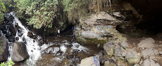 |
| A few people exploring the caves. |
My late start to my explorations put me about dinnertime as I was leaving the waterfall, so after going back to the hotel and showering I headed back to Bar Red to talk to the guys there again. I called it an early night with a planned morning of riding that was... adventurous, to say the least.
When I'd talked to the owner of the hostel about things to do the day before, he'd asked if I was going to Quito next. When I said yes, he said there was a really cool way to get there on some back roads. "Come on over and lets pull up Google Maps," he says. Then he puts the webpage in satellite mode and starts pointing out little lines between the trees in the pictures. Those little lines are apparently the roads I'm supposed to be taking - they're not shown on the "road map" version. I marked a few stars at the major turns, and hoped I could manage to not miss them. I asked how the roads were, and he said he'd taken them in a car before so they're not too bad.
So in the morning I headed up into the mountains. At first, I had an interesting cobblestone road, but it turned to dirt right about when I arrived at one of the three lagunas that are tucked up within the peaks of the mountains there.
 |
| Bumpy, but not too difficult of a ride. |
 |
| The big laguna. I saw a couple groups of people hiking around here. |
 |
| The area was primarily grassy highlands, with rocky peaks sticking up out of the landscape. |
As I continued further, I almost missed one of the turns - because the "main" road continued on, and the one the hostel owner had recommended was pretty messy mud. Though it wasn't raining, it had rained quite a bit the day before, and the low clouds and humidity kept the ground from drying out too much. That left me with parts like this, which I'd be really surprised if this guy had actually traversed in a regular car.
 |
| Everything to the left is a few inches of super soft mud, and quite a bit steeper than it looks in this picture. I gunned it and made it up okay, but I can't imagine a sedan making it up this road. |
The road swept past the two other lagunas (no pics, sorry) on more muddy, muddy roads, but the reward was worth it - I continued onward and met up with the main road where I found the viewpoint he'd mentioned. In one direction there was a nice high view of the largest laguna, and in the other a view of the cities that line the Pan American that I would have taken otherwise.
 |
| The main laguna, with the clouds sweeping over. |
 |
| The other direction. |
 |
| I was parked next to these peaks which kept disappearing and reappearing as the clouds moved over. |
I snaked down the other side of the mountain on dirt switchbacks, fortunately a little drier on this side, and then continued down to meet up with the Pan American again. I was riding somewhat map-less at this point, as I was still in a region that Google Maps hasn't added any roads to, yet out of the region that I'd loaded up the satellite images for. But the route was pretty straight forward. That is, until I ran into a problem.
 |
| These guys fortunately weren't too much of a problem - the guy behind them was herding them from his motorcycle. |
 |
| This, however, is a bit of a problem. |
Apparently a truck had lost traction and slid backwards, blocking the entire road. I looked for a place to squeeze by, but there wasn't much with an embankment on one side and a barbed wire fence on the other. So I headed back up the hill and took a turn where I'd gone straight before, heading parallel to the Pan American in hopes of finding another road down to it.
Fortunately I found one (with a little help from a car driving by as I sat confused at one intersection) and after cutting through a small town I found the highway - and what a gorgeous highway it was. Freshly paved, twisty, and stuck to the side of a mountain, I cruised my way down into Quito where I rewarded myself for the hard riding day with a Big Mac at McDonald's.
Ecuador was already turning out to be more than I had expected - more beautiful, more awesome roads, more interesting - but there was still more to come in Quito.


No comments:
Post a Comment